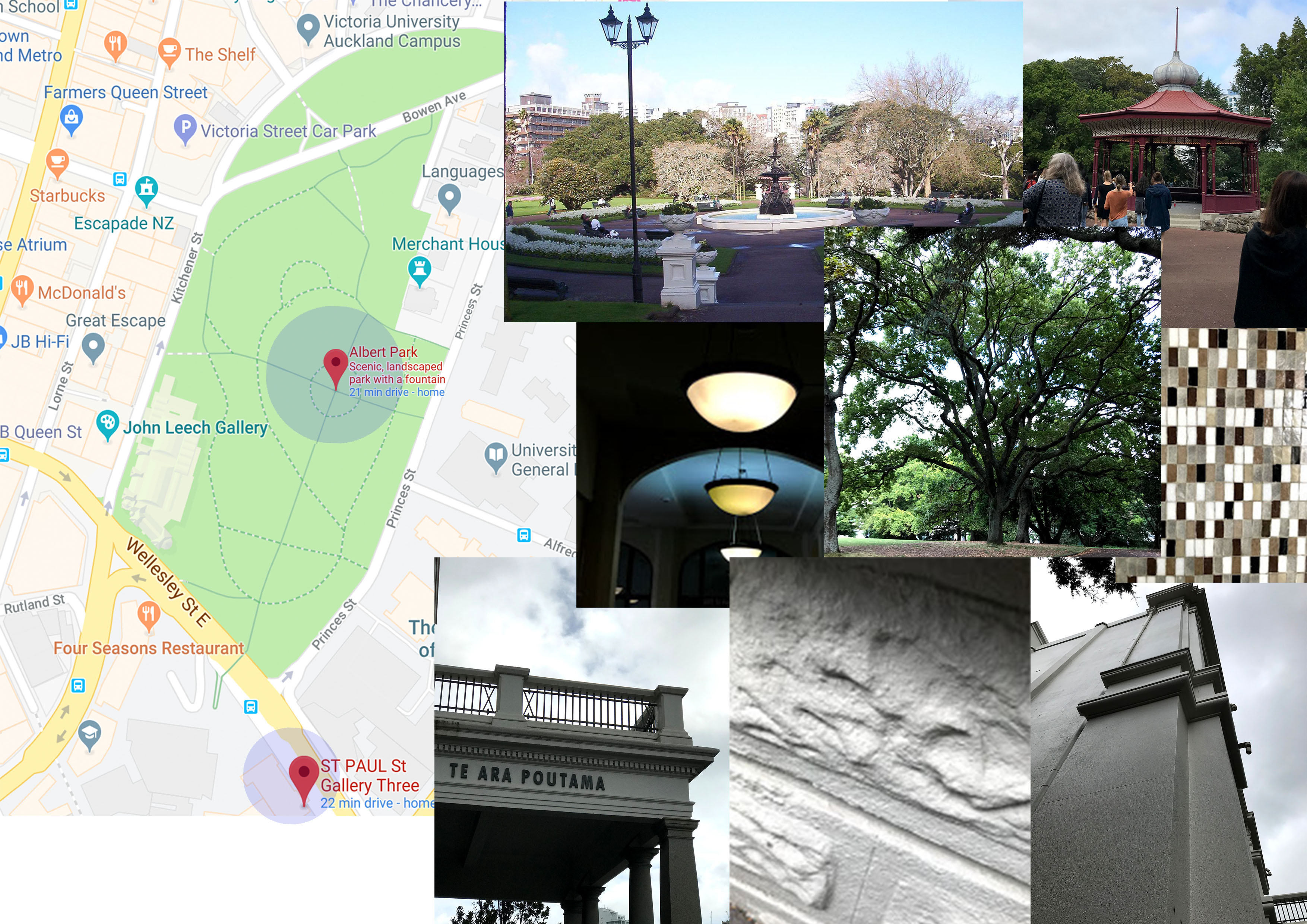
For our second project we are creating sleep/ wake: site mapping: threshold. The first day we visited 2 sites that are both completely different from each other first one was Albert Park an open/ exterior threshold intimacy while the second site was inside the St Paul st Gallery Three a close/ interior threshold intimacy. I have included images below that I have taken during that day, and i’ve also provided the site map of both sites.


Below are the quick sketches i’ve done during looking at the site in person
Albert Park:


St Paul st Gallery Three:


History of Albert Park
Albert Park in Auckland was a military barracks during the conflict in Northland from 1845 to 1846. Troops were stationed there until 1871, when most of the buildings and walls were demolished. The park itself was constructed 10 years later.
The hill was created around 60,000 years ago from the ash of a volcano whose crater was approximately at the intersection of Victoria street east, Bowen Avenue, and Kitchener street. The area was known as Rangipuke by the original Maori settlers. The hill was a settlement of around 160 people, there was a pa on the northwest part which was called Te Horotui referring to an old landside. After the European colonisation the hill became a defensive post against Maori attacks. The army base was located there between 1840 to 1850. It comprised of a stone wall surrounding over 9ha of land including part of the current University land. Fighting never reached the barracks. After the army left the hill reverted to the City Improvement Commission who designated it as a public park and designed the roads and paths. The commission was strapped for funds and little development was done until the Auckland City Council took mover the site in 1879. A competition was held to design the layout, the winning entry was by James Slater. By 1880 the old barracks had been removed, paths, and gardens laid down and fountain built. During World War II the old ornamental cannons were buried and air raid shelters built under the hill.
During World War II New Zealand was under threat of invasion, and the need to build a public air raid shelter became pertinent.Albert Park was selected as the best site an an enormous complex of tunnels was built in a short period of time. The tunnel complex was designed to house the entire daytime population of central Auckland in the event of an aerial attack. Overall, there are over 3.5km of tunnels and passages in the complex underneath Albert Park, the University of Auckland and Constitution Hill Reserve. The main tunnel is 660m long, running from the corner of Beach Road and Churchill Street in Parnell right through to the top of Victoria Street in Central Auckland. The larger tunnels are 4.4m wide and 3m tall, built large enough to drive a supply truck through, with a network of smaller side passages serving as bunk rooms, first aid stations and stores. They were dug by 118 men using simple tools and hand carts to cut through rock and soil, working in shifts around the clock to complete the job in just three months. They were lined with native timber beams and boards in an arch shape for stability, and drained with terracotta pipes and scoria floor. Three parallel portals were built at Victoria Street, and another three at Beach Road, all fitted with blast baffles. Additional entrances and main tunnels linked to Kitchener Street (near the Chancery), Wellesley Street opposite AUT, and to the area now occupied by the forecourt of the Auckland Art Gallery. Several brick shafts were built for ventilation across the tunnel complex, including ones in Albert Park, near Princes Street and Symonds Street, and in the grounds of the Old Government House. Rumours exist of secret entrances linking the tunnels to the government building, and even trapdoors leading from the Albert Park band rotunda, and even a passage in an old well. Fortunately, the tunnels never needed to be used for their intended purpose, although they were kept well stocked during the war and numerous air raid drills were conducted to ready the population for the risk of attack. In particular students of the Seddon Technical College (now the Auckland University of Technology) practiced filing in and out of the tunnels across Wellesley Street. The end of the war raised the question of what to do with the tunnels, and a range of schemes including tram tunnels, road links, car-parking and even mushroom farming were proposed. However at the end of the day the post-war government had little money to invest, and the tunnels were filled up with millions of clay blocks and the entrances walled over, to be forgotten.


Rotunda:


The rotunda was built in 1901, design by James Slater the winner of the original design competition for Albert Park. It replaced an earlier bandstand which was located at the site of the current Queen Victoria statue. There is an unexpected relationship between the rotunda on the surface and the air raid shelter underground. Tunnel 1 intersects the paths around the rotunda like a spoke (normal to the circle) and stops directly under the rotunda.
Concept & A1 site map:
For my project I have chosen a few spatial designers that have the same idea that i was thinking of making for my model, which are: Sou Fujimoto & Junya Ishigami. Both designers have the same concept of exploring unnatural designs that are quite unique at the same time these designs also produces such shadows during day time that are nice. And since for my previous project my A2 threshold image was mainly focused on the shadows of my model so therefore I wanted to incorporate that for this project.
Below are some images of the spatial designers work
Sou Fujimoto:


Junya Ishigami:
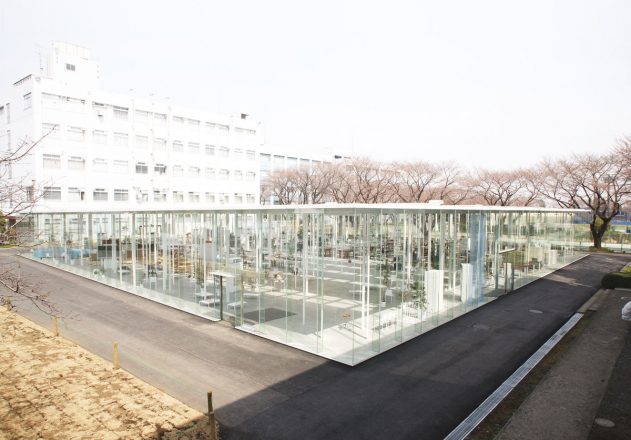

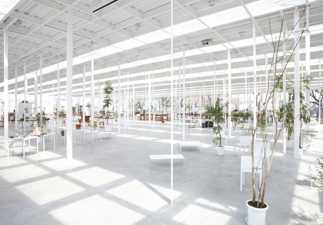
Both designers have the same interests in what shadows their designs produces as well as this minimalistic look.
For my model i decided to focus more on the idea of light and dark, meaning that the shadows that’s produced by my model is the dark and the light is the light source for my model that makes the shadows. For my model i wanted to incorporate the different stages of sleeping as i explained from my previous project idea. And also the idea of fragility.
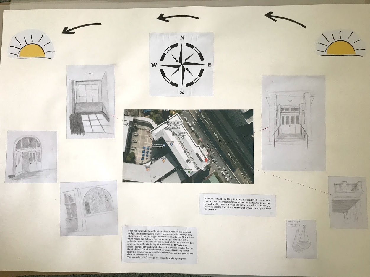
Below shows my A1 site map which showing the key thresholds of the gallery site and my own experience entering and exiting the gallery space. Where it shows the direction of the sunrise from east and sunset from west from where the gallery is built.
When you enter the building through the Wellesley Street entrance you enter into a low lighting room where the lights are dim and not as much sunlight filters through the entrance windows and door, as there is a balcony above the entrance that prevents sunlight to filter the entrance.
When you come into the gallery itself the NE window has the most sunlight that filters through it which brightens up the whole gallery when the sun is out and bright. Before there used to be a SE windows which results the gallery to have more sunlight coming in to the gallery but now those windows are blocked off. So therefore the light source of the gallery is the big NE window as the NW windows doesn’t provide any sunlight at all cause it’s another interior that has the dim lights. The NE window that looks out of Wellesley Street, from this window people outside can clearly see you and you can see them, as the window is big. The room also echo’s through out the gallery when you speak.